A2 IN GREENSTREET - THE FACTS
THE A2 IS NOT A TRUNK ROAD - STOP PRETENDING IT IS!
SIMPLE TRUTH: ALL new developments approved by SBC Officials and Councillors that connect to the A2 must logically add pollution to the AQMAs. That pollution will be much higher, more quickly where traffic has to slow down and experience congestion due to the increased loading of traffic when it meets other traffic, road users. and pedestrians.
Department for Transport classification of major roads to receive additional funding
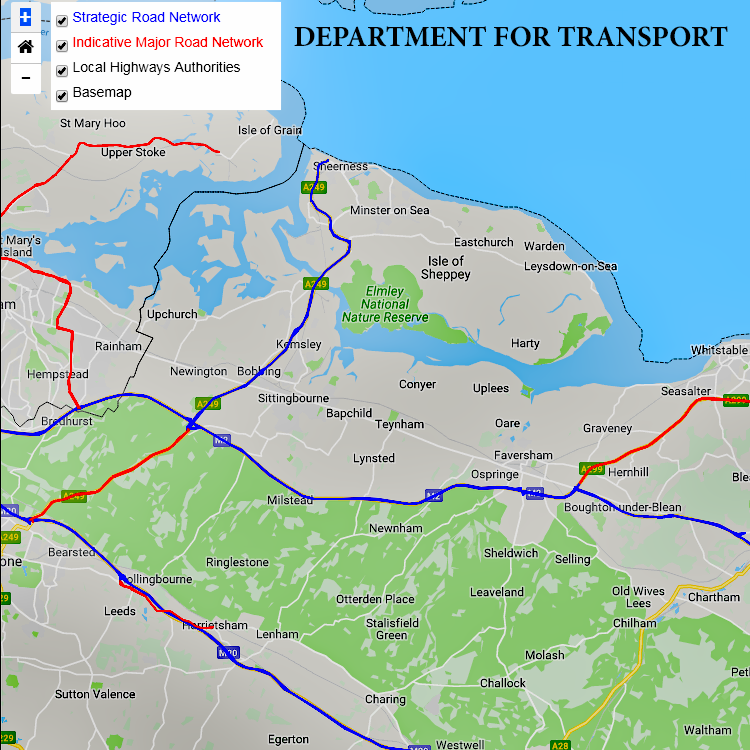 Government Investment. The A2 between Sittingbourne and Faversham is excluded from the Department for Transport (DfT) map of Strategic Road Network and new proposals for funding of "Indicative Major Road Network". The Consultation ended in 2018. The Government Response is listed on our "Official Documents" page. Central Government is looking to local authorities to plan for local and regional prosperity rather than a box-ticking exercise meant to meet quotas using lucrative greenfield sites.
A rational analysis of the roads needed to support housing and prosperity in our part of Kent Kent excludes the strangled "backwater" of our part of the A2.
You may notice that there are plans to improve links between Maidstone (M20) and the M2 onwards to the Isle of Sheppey. This funding is not consistent with SBC ambitions to add a diversion throug a garden town to the congested A2.
A more logical approach would be to improve link roads from the industrial estates of Sittingbourne to the A249 to take light van and HGV traffic away from rural communities served by the "backwater" part of the A2.
SBC preference for filling in between the A2 and M2 and to the boundary of Lynsted with Kingsdown, taking in parts of Tonge Parish and Bapchild is explored under "Fake News".
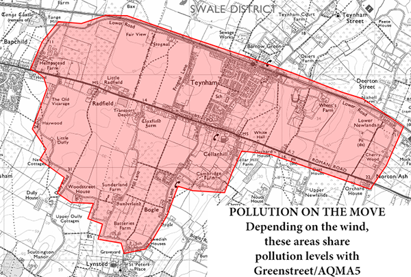
THE "LOOK AND FEEL" OF GREENSTREET (AQMA5)
1. We are all in it together, not just those living along the A2
Reality Check: The homes most harmed by poisonous levels of pollution were built on traditional lines, front doors adjacent to the road. This is especially true in Ospringe, Teynham and Lynsted with Kingsdown and not to forget Newington. However, the emerging picture from regular pollution measurement and mapping shows how the pollution along Greenstreet spreads significantly to the north and south of the A2 as well as east and west of our parish boundaries.
So, the creation of pollution may be driven by vehicles along the whole length of the A2 in Greenstreet, but that pollution is being experienced more widely than you might imagine - throughout Teynham and into Lynsted with Kingsdown to take in Cellar Hill and the built up parts of Lynsted Lane. Take a look at the Pollution Diary.
Swale Borough Council placed Diffusion Tubes at the roadside in four locations to begin with:-
- SW79: Belle Friday Centre
- SW80: Michael's Hairdressers - 107 London Road (595160 162470)
- SW91: adjacent to 72 London Road (595451 162446)
- SW92: FJ Williams, 64 London Road (595195 162446)
... later removing SW79 (perhaps because Age UK buses bring traffic to a stop for extended periods of time? Academic now that Age UK are closing the service) but adding:-
- SW99: Frognal Lane (594790 162600)
- SW100: Frognal Lane (Urban Background - 594818 162647)
- SW101: Lynsted Lane (595131 162463)
- SW102: Michaels (595206 162457)
- SW103: Station Road (595310 162439)
Until challenged during an SBC Focus Group (8th January 2019), all the tubes were placed far too high, leading to under-reporting for AQMA5. The tubes are now closer to head height.
2. Choking already and it will get worse! Draft SBC Local Plan Impacts (Reg19)
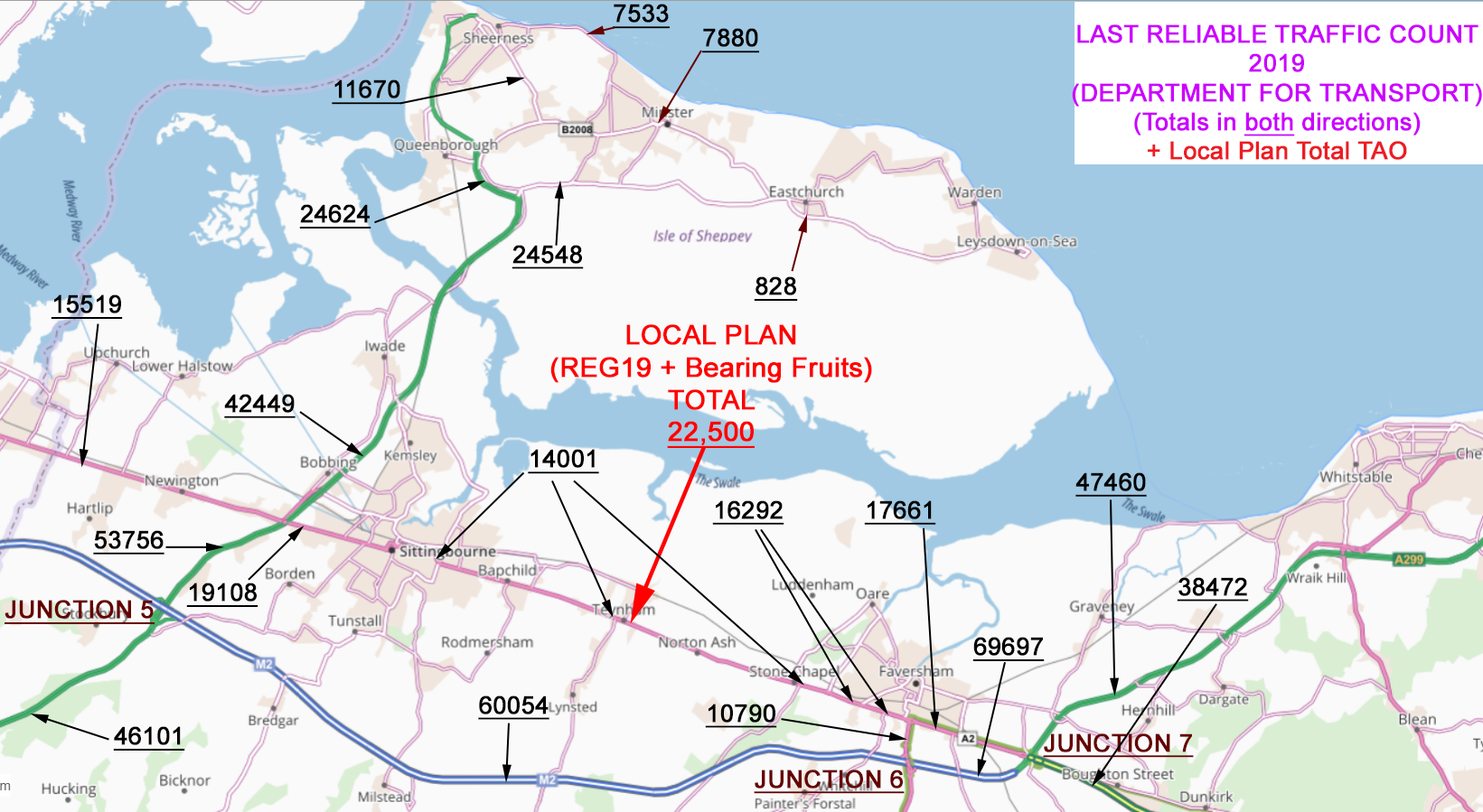
Existing housing and commercial approvals are already having an impact on traffic flows along a struggling A2. These households will generate approximately 2 vehicles each - that is, at least, 22,000 vehicles doing pretty much what our existing car owners do - delivering pupils to schools, shopping, commuting, using local services, starting and finishing longer journeys towns and cities.
Ordinary people today go about their business and we/they are already causing harm. Adding more people into the mix will not change the driving behaviour of Swale residents, workers and visitors. Our needs remain the same - school runs, commuter trains, offices, shops, medical practitioners, tourism. SBC has no public transport policy worth the name.
Faced with punative housing allocations in the 'closed system' of the A2 Corridor between Sittingbourne and Ospringe, the three Air Quality Management Areas at Sittingbourne (East Street), Teynham/Lynsted, and Ospringe Street will see a 50% increase in traffic loading.
Swale Borough Council are being devious
While we wait to see which way Swale Borough Council will jump on the Local Plan, I thought I should revisit the daily number of vehicles and bracket the "likely" outcome and the "worst case scenario" if all allocations are made - "Bearing Fruits" + REG19 Local Plan update. I believe that Swale Borough Council are being dishonest with our communities by promoting Teynham Area of Opportunity (TAO) without including the obvious 'down-sides'. They have done all of this without any evidence or analysis. The best that can be said is SBC is using idiotic guess-work.
The massive uplift in housing for this rural setting, trapped on the A2 between Faversham and Sittingbourne, WILL create 22,500 new vehicle movements EVERY DAY using existing data.
However, CPRE's recent research into bypasses tells us that bypasses add up to 40% more vehicles, without any more houses! In our "real world", the daily numbers stack up a world of pain for future generations. Daily 22,500 vehicles may increase up to 40% (because of the bypass) creating a catastrophic 31,500 vehicle movements every day (add 25-years worth of 200 daily HGVs for brickearth extraction at Barrow Green Farm) and we get an eye-watering 32,000 vehicles through the A2! That will be catastrophic for Teynham and Lynsted (not all traffic will use the bypass rather than go in a straight line along the A2 and SBC wants Teynham Village to convert two cul-de-sacs to through-traffic). Our neighbours in East Street and Ospringe Street will get the full force of this traffic too.
Only an idiot would believe that buses, trains and walking/cycling ("active travel") will make a dent in that many people leading their day to day lives. Frankly, SBC comes out of this exercise as devious and incompetent. Map.
3. Distribution of AQMAs and SBC chooses to ignore "cumulative impact"
The map (above) shows the burdens being carried by our communities along the struggling A2. The National Planning Policy Framework (2018) tells Local Authorities that every planning decision should be assessed in terms of their "cumulative impact" on existing AQMAs. Swale Borough Council seems to be blind to it's responsibilities for the health and well-being of residents and workers in and close to AQMAs.
4. The Shape of the A2 in AQMA5
The A2 for us is bracketed at each end by the urban areas of Sittingbourne and Faversham. The traffic gets slowed and stuck in the built-up sections of the A2 - Greenstreet and Ospringe. The Department for Transport excludes this section of the A2 from Government thinking on expanding the Major Road Networks.
The loading of traffic along Greenstreet regularly overwhelms its capacity. It leads to very frequent periods of "Very High" (Purple) pollution as vehicles slow down, brake and accelerate to negotiate traffic joining from north and south of Greenstreet. They also have to negotiate parked cars, cyclists, delivery vans and lorries, as well as pedestrians trying to use (and keep) shops on the A2. Visit the Pollution Diary to see how often our air is "Purple" for more than an hour at a time. These figures are not made up, they based on an analytical device that plugs the gap left by SBC, who refuse to do it themselves.
5. Canyon Effect in Greenstreet.
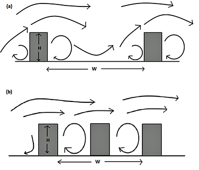 If wind blows across the A2 in Greenstreet, it can trap and concentrate pollution at ground-level. This helps explain some of our experience of High and Very High pollution. This image helps show the mechanism.
Our conditions are closer to the kind of spacing in Example (b).
But this is not the whole story. Pollution can travel over great distances and it is this variability that makes it difficult to 'unpick' the exceedances of some pollutants with changes in wind direction.